The Hypsometry Toolbox contains:
- Hypsometric Curve : derives hypsometry (area / elevation) for a watershed elevation raster.
- Area Gradient tools : derives a table of watershed area, stream gradient, and hypsometry.
- Max Watershed : derives the largest watershed, for input to other tools.
Purpose:
The hypsometric curve (area–altitude relation) of a watershed has been used since the 1950s to describe the distribution of watershed area with elevation, usually as a proportion of area above each proportion in elevation. A related analysis is between watershed area and stream gradient. These tools create multiple indices that can be used in the analysis of hypsometry, gradient and watershed area.
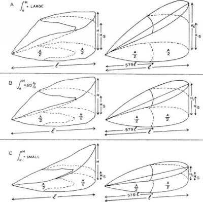
Hypsometric Integrals related to watershed shape. From Chorley and Morley (1959).
Hypsometric Curve
Computes hypsometric data for curves and integral. The hypsometric curve (area–altitude relation) of a watershed was first introduced in 1947 by Langbein, and was further developed by Strahler (1952) to employ proportional heights and areas so as to make each curve comparable and independent of units. Strahler also proposed that the dimensionless hypsometric integral might be used as a measure of landscape evolution. More recently hypsometric analysis has been used in the context of tectonic geomorphic analyses of uplift history. Output raster has proportional area and elevation for graphing hypsometric curve.
Parameters:
- Input raster elevation model. Elevations must be in same units as horizontal map units.
- Output hypsometry raster. Sliced into 100 equal interval proportions of elevation, coded as PropElev (0 to 1) and PropArea (0 to 1).
- Hypsometric Integral
Chorley, R. J.. and L. S. D. Morley (1959). A Simplified Approximation for the Hypsometric Integral. J. Geology 67, No. 5, pp. 566 ‐ 571
Langbein, W. B. (1947) Topographic characteristics of drainage basins. United States Geological Survey, Water Supply Paper 968 ‐ C, 125 ‐ 157.
Strahler, A. N. (1952) Hypsometric (area ‐ altitude) analysis of erosional topography. Geological Society of America Bulletin 63, 1117-1142.
Area Gradient Tools
The purpose of these three tools is to derive hypsometric and gradient values for a sequence of points along the main drainage path of a watershed. The tools differ in how they define the main drainage:
- Area Gradient Highest Order uses the highest ‐ order channel.
- Area Gradient finds a channel path that flows from the highest elevation (MAXELEV), the maximum flow ‐ length point (MAXFLOWLENGTH), or a chosen point (SNAPPOURPOINT).
Each creates a CSV file that can be opened in Excel or joined to the strElevArea.shp file in ArcMap using id. Other fields:
- wshed_area : area in square map units (e.g. m 2 ) of the watershed detected above that point.
- prop_area : proportion of the total watershed this represents.
- str_gradient : stream gradient (m/m) between each point and the point next upstream.
- avg_gradient : running average of 3 stream gradients.
- avgdist : the distance over which avg_gradient was measured.
- dist : distance upstream to the next point.
- cumul_dist : cumulative distance.
- x, y, z : coordinates · h = (z ‐ minElev)/rangeElev
Note: This tool creates a temp folder in the input elevation raster’s workspace. This temp folder is automatically deleted at the start, then recreated with new data.