Using Habitat Risk Assessment to Assess Disturbance from Maritime Activities to Inform Seabird Conservation in a Coastal Marine Ecosystem
ABSTRACT
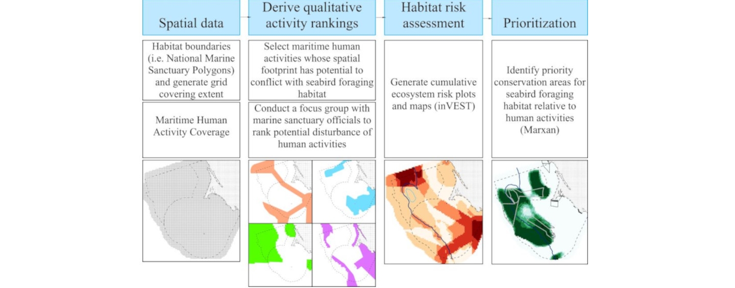
Habitat prioritization is a powerful tool for identifying critical wildlife areas for conservation. This study evaluates the risk of disturbance from maritime activities to seabirds in order to prioritize critical seabird foraging habitat for conservation thereby providing a much-needed methodological contribution demonstrating how to transparently incorporate metrics of “cost” based on risk to support ocean zoning. We standardized and combined predicted seabird distributions for six nonresident species foraging in the non-coastal “offshore” waters in the Greater Farallones National Marine Sanctuary and Cordell Bank National Marine Sanctuary, which we predicted using ten years of Applied California Current Ecosystem Studies (ACCESS) at-sea data for the month of July. We obtained maritime activity data from the California Ocean Use Atlas, whale-watching data, expert consultation, and primary literature. Activities included benthic fishing with fixed and mobile gear, military operations, oil spill, shipping, and whale-watching. Risk calculations were based on management effectiveness, spatial and temporal overlap of activities with seabird distributions, changes in area, and severity of negative impacts. Of those activities evaluated with the InVEST Habitat Risk Assessment (HRA) model, higher risk activities were oil spill, benthic fishing with fixed or mobile gear, and military activities. Looking at all risks spatially, highest cumulative risk areas concentrated to the north and northeast of Cordell Bank, along segments of the shelf break, and along areas of the shipping lanes. We demonstrated the use of the HRA tool to quantify costs for use in Marxan habitat prioritization software. The HRA model provided a transparent and replicable cost metric that partitioned risk into exposure and consequence. This approach provided two options for meeting high priority seabird foraging protection goals in the Sanctuaries: 1) protecting the low cost Marxan-prioritized areas or 2) managing high risk maritime activities highlighted by the HRA model. Waters around the Farallon Islands, nearby and northeast of Cordell Bank, and to the southwest of the continental shelf break in the southern region of Greater Farallones National Marine Sanctuary were identified as areas where seabirds would benefit from a combination of adding protections to some low cost Marxan-prioritized areas and enhancing management of the primary disturbance resulting from higher risk activities of oil spill, benthic fishing with mobile or fixed gear, and military activities, each of which have spatial footprints contributing to high cost Marxan prioritized areas. Either approach could be scaled up to include a larger habitat area, multiple habitat types, and different maritime activities. Our methods can be applied globally to improve ocean zoning where critical wildlife areas are threatened by human activities.
Read full article: